“compiled: Elmili TK”
Africa Map Projection controversies are resurfacing as advocacy groups push schools and organizations to replace the distorted Mercator map with the Equal Earth projection. The movement, recently endorsed by the African Union, highlights the importance of showing Africa’s true size and global significance.
Africa shrinks on the Mercator map
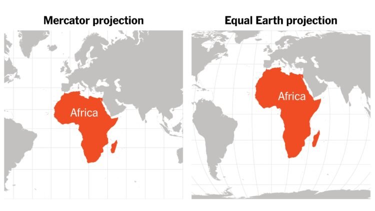
The Mercator projection, created in the 16th century for navigation, dramatically enlarges regions near the poles. As a result, Greenland looks as big as Africa, even though Africa is 14 times larger. This distortion makes Africa appear far smaller than its real landmass, diminishing its importance.
By contrast, the 2018 Equal Earth projection follows the Earth’s curvature, displaying continents in their true proportions. Advocates argue this correction is crucial for global education and fairness.
African advocacy groups lead the campaign
Two advocacy groups, Africa No Filter and Speak Up Africa, launched the “Correct The Map” campaign in April. They urge schools, international organizations, and media outlets to adopt the Equal Earth projection.
Fara Ndiaye, deputy director of Speak Up Africa, stressed that correcting maps is about truth, not politics. “When generations learn from distorted maps, they develop a biased view of Africa’s role in the world,” Ndiaye said.
He emphasized that a minimized Africa downplays its demographic, economic, and strategic weight in global affairs.
African Union endorsement marks milestone
On August 14, the African Union formally endorsed the campaign, making it the largest institution to support the effort so far. Advocates hailed the move as a turning point in the push to correct Africa’s global image.
Experts call Mercator projection outdated
Geography professor Mark Monmonier of Syracuse University noted that the Mercator map is obsolete. “It was useful for 16th-century sailors, but outside navigation, it serves no purpose,” he explained.
He added that while Equal Earth maps improve accuracy, irregular land shapes still make comparison difficult. For exact size comparisons, bar graphs work best.
A push for global accuracy
Supporters believe replacing outdated maps can reshape global perceptions. They argue that accurate Africa map projection is not just an African issue but a global necessity for truth and fairness.

 English